Table of Contents
About
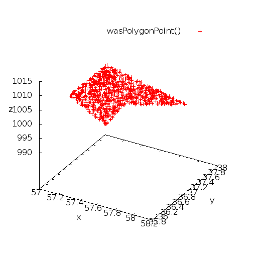
The following program is meant to create a primitive that will travel within a specified polygon (or, in civil engineering, a specified perimeter). This program works differently from other wanderer point generators because the polygon itself is strictly defined in the code - that is, the example below uses the following points that define a two-dimensional concave polygon:
57.59832, 36.773457, 1004.033325
57.642971, 35.974648, 1004.033325
57.065857, 36.585957, 1004.033325
57.065857, 37.845955, 1004.033325
58.10437, 37.301346, 1004.033325
Uses
Different uses come to mind:
- In Second Life we may want to establish a perimeter for some animal to move without entering the house - or perhaps even entering the house, but avoiding going through the walls.
- A different use could be a lawn mower that could be pre-programmed to autonomously mow the lawn without colliding with the house walls.
Graph
Video
Wanderer Algorithm
The algorithm is an accept-reject data sampling algorithm that first generates points within a circle circumscribing a polygon and then accepts all the points that fall within the polygon.
- First find the centroid from the polygon data points. This is called the smallest circle problem but we have made our own algorithm. For more details, please see the finding the centroid chapter below.
- The distance from the centroid to the point furthest away in the polygon data points can be used as a radius to circumscribe the polygon in a circle.
- Now, we can generate points within that circle by using
wasCirclePoint. - Using the PNPOLY (ray-cast) algorithm, we can now determine whether the points generated in that circle are also inside the polygon. So, generate a point within that circle using
wasCirclePointand then:- If it is within the polygon, then that is a valid accepted point.
- If it is not within the polygon, then loop until we get a valid point.
The elegance of this algorithm is given by the fact that only the polygon points have to be known and that everything else is computed at run-time.
Shortcomings
For very nasty polygons with very acute angles, the circle circumscribing them will have a very large area compared to the area of the polygon. If this happens, then the algorithm slows down because the points generated within the encompassing circle will stand a low chance to also fall within the polygon.
A second ray-cast has to be performed to check whether the wanderer collides with a boundary. This is because the LSL code only generates points within a polygon which the wanderer then takes as the next destination. In doing so, the generated points using our algorithm do fall within the polygon but the movement of the wanderer may collide with the boundaries along the path between the current position and the next generated point. At first, we generate a point within the polygon:
moveTo(wasPolygonPoint(polygonPoints));
which makes sure to move the wanderer within the polygon and when the point is reached, then we generate the next point while also checking whether the path would intersect the boundaries:
moveTo(wasPolygonPath(llGetPos(), polygonPoints));
Finding the Centroid
The centroid of a polygon - or rather, any set of points, is defined as a point that is placed within that data-set so that the distances from that point to all other points is minimal. You can visualize this the following way:
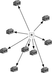
Suppose you have a scattering of houses on a field. You want to place a hospital (marked with H in the image) so that the hospital is placed at the minimal distance to all points. That means that some of the houses will reach the hospital faster, but that overall the distances from the houses to the hospital are minimal. This is illustrated by Marc van Kreveld in his computational geometry slides along with similar other problems.
Smallest Circle Algorithm
The most common way of finding the centroid from a data set of points, reduces to the smallest circle problem. The solution to the smallest circle problem is quite difficult (albeit clever) because it involves a lot of complication in drawing and moving circles. It is also not a definite algorithm - in the sense that it involves looping around until some condition is smaller than a calculated threshold which guarantees termination. Jacob Eliosoff and Richard Unger give a proof for this algorithm, demonstrating that the algorithm works and indicate that it is an  algorithm.
Our Own Algorithm
We have chosen to create our own algorithm (see Zenos paradox on the race between Achilles and the Tortoise for inspiration) for finding the centroid, and we will illustrate it here:
- Given a set of points, select any point from the set and call it
 .
. - Calculate the distance from the selected point
 to all other points and select the longest distance.
 - Move
 along the longest distance by
  of the distances length.
 - Now loop at 2 and do the same, moving
 along the farthest distance by
  , every time decreasing how much to move along the longest distance, until the distance between the ideal centroid and the approximated centroid using this method falls within a user-specified threshold.
Series used for approximation:  where
where  (absolutely convergent geometric series).
Similar to the Jacob Eliosoff and Richard Unger method the algorithm requires a threshold for termination. In our case, the threshold given by the user represents the distance between the ideal centroid and the centroid approximated by this algorithm.
Compared to the Jacob Eliosoff and Richard Unger method, our algorithm is "much much"™ simpler to implement since it just requires ... division and addition.
Our algorithm performs an iterative refinement / approximation of the centroid such that upon every iteration, the position of the centroid is better estimated. In other words, iteration  of our algorithm will provide a better estimation of the centroid than at iteration
  . Given a desired precision (the upper threshold) our algorithm should have the same quadratic complexity
  .
.
In pseudocode:
select any point p = p1 from p1,p2,...,pn
for i = 2 to m where m is a desired approximation
    // compute largest distance d from p to all other points p2,...,pn
    let d = 0
    let pm = p1
    for j=2 to n
        k = distance from p to pj
        if d < k
            set d = k
            set pm = pj
    // move point p
    move p towards pm by d / i
    let i = i * 2
The first complexity represents the algorithm runtime from  to
to  whilst the second is a repetitive complexity to determine the largest distance from the current point position to all other points thereby yielding
  time complexity in total. Perhaps there is a way to eliminate the inner loop based on what is already known to achieve
  time complexity.
Proof
Hypothesis: when  then the centroid will be found.
Perhaps a proof could be constructed inductively over the number of points.
One Point
For one point  , the distance from
  to itself is
  such that all terms of the Zeno series
  ,
,  ,
,  reduce to zero and the centroid
  coincides with point
  .
.
Two Points
For two points in space (defining a line):
A (x1, y) ----------------------- B (x2, y)
Such that the centroid (midpoint, in 2D) is to be found at  :
:
A (x1, y) ------------x---------- B (x2, y)
                 C (x1+x2/2, y)
Note that the distance from  to
to  is equal to the distance from
  to
to  such that any path can be chosen as a starting point (follows by applying the distance formula
  and substituting such that
  and
and  resulting that
  ).
).
Picking one of the two segments from  to
to  or
or  to
to  , say
, say  , the first step is to move point
  (and rename to
  ) by
) by  towards
  where
where  represents the length of the segment
  :
:
              Z ((3*x1+x2)/4, y)
A (x1, y) ------x-----x---------- B (x2, y)
                 C (x1+x2/2, y)
 will thus have the coordinates
  . From the next iteration on, the algorithm will always pick the segment
  since the segment
  will always be larger than segment
  until
until  (in other words, when point
  will coincide with point
  ; at which point
  ).
).
As we move the point  along the segment
  from
from  to
to  , we have to show that by applying the algorithm at every step we will eventually reach point
  .
.
First step, for going  from
from  to
to  , we compute
  and knowing that
  is at
is at  we obtain that:

Further Ideas
Minimizing Reject Points
In the previous section we circumscribed the polygon into a minimal circle and then we would generate points within that circle later checking if the points also reside within the polygon. However, if we were to determine the minimal enclosing ellipse then the reject points could be further reduced.
In order to optimize the algorithm, the problem will shift to determining the minimal enclosing ellipse and then generating points within that ellipse and checking whether those points are within the polygon as well.
A polygon-point generator that uses an ellipse generator described in this section is now available on the ellipse polygon point generator page.
Probabilities
Measuring number distributions by observing where the wanderer tends to go?
    +------+                 +------+
   /        \               /        \
  /   ->     +-------------+          \
 +    w                                +
  \          +-------------+          /
   \        /               \        /
    +------+                 +------+


